12th of Rabî’ al-Awal is an important holiday for Sufis, it’s the ‘Ayd al-Mawlid, the Birthday of the Prophet Muhammad (saaws). Moroccan shrines mark the day in a variety of ways: all-night vigils, processions, feasts, displays of horsemanship (called fantasia) and pilgrimages (called moussem Moroccan Arabic, mawsim in standard). Moussems often have a festive and playful atmosphere, especially in rural ares. The Mawlid holiday is therefore a good occasion to explore some of the shrines involved.
In cities, shrines are often located near gates, or next to specific manufacturing or commercial structures. In the countryside one encounters shrines at the summit of ridges or next to specific rock outcrops or natural springs, and they are often associated to trees and groves.
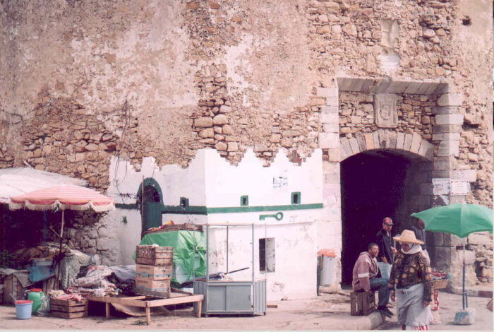
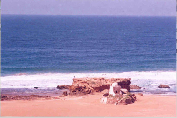
The tiny shrine of Sidi Mifta (My Lord Key) in Asilah stands outside Bab El Homar, one of the city’s gates (ph Eric Ross)
Shrines come in a variety of sizes and shapes and go by a variety of designations. I am indebted for typology that follows to Vincent Cornell’s Realm of the Saint.
Most shrines are associated with burial:
- A darîh is a mausoleum, a roofed structure over a tomb. A small darîh will usually be crowned by a dome (qubba in Arabic) and will be whitewashed regularly. Darîhs are often located within cemeteries.
- A zâwiya is a Sufi institution and is larger and more complex than a simple darîh. It consists of a mosque or designated prayer space and often includes the mausoleum of its founder. Major zâwiyas will also contain a hostel for pilgrims, quranic schools and other ancillary buildings. Most often zâwiyas, like mosques, are roofed in green glazed tile, and the dome over the tomb chamber will be encased beneath a pyramidal roof.
- A ribât originally referred to a fort erected to protect an exposed border. Numerous ribâts were set up along Morocco’s Atlantic coast, and at the mouths of rivers especially, to protect against Norman raids in the 9th century. These ribâts constituted small communities of volunteer fighters and some later developed into full-fledged Sufi institutions. They survive today mostly in toponymy. For instance, the name of the capital of Morocco derives from just such a settlement. Ribâts were built on similar sites along the Mediterranean coast.
- A khalwa is a spiritual retreat. Many Sufis have felt the need to isolate themselves from worldly concerns and distractions and have settled, at least for a time, in appropriately isolated places. Ironically, some of these khalwas later developed into shrines and thus have attracted people and activities.
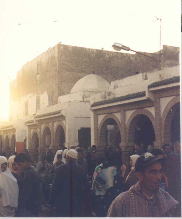
The Derqawiya Zâwiya in Essaouira stands in the butcher’s market (ph Eric Ross)
Important shrines rarely stand alone. There will be ancillary shrines located in the vicinity. In other words, shrines come in clusters. As for the saintly individuals buried in these shrines, they go by several designations:
- Sîdî (“my lord,” in the feudal sense of the term, Mon Sieur) is the most common.
- Sâlih or Sâlah refers to the piety of the saint.
- Wâlî, both “friend of” and “befriended by” God.
- The title Mawlay (more commonly “Moulay” another term for “my lord”) is reserved for sharîfs, descendants of the Prophet Muhammad (as Morocco’s reigning dynasty is sharîfî, the term Moulay is also applied to princes).
- The female equivalent of all these terms is Lâlla, an Ottoman title
While in many cases the identities of the saints can be verified in historical texts or other sources, in some others the saint appears to be a generic manifestation of saintliness rather than an actual individual. The histories of some of the saints discussed below are known, but I must admit that I have not been consistent in accurately recording the identity of all those I have encountered in the field. It appears to me that the shrines of most of the “generic” saints are precisely those which seem to mark crucial topographical features, be they urban, rural or natural.

Part of Morocco’s Atlantic coast, showing location of shrines discussed in this post.
Shrines along Morocco’s Atlantic coast are particularly interesting in that they seem to mark specific elements in the interplay of land and sea: capes and bays, rocks and islands, the entrance to estuaries, etc. As with many Shinto shrines in Japan, the original topography of these sites appears to have determined their transformation into religious places. For more on this theme see an article by Mouna Hachim in Morocco’s L’Économiste.
What follows here is an inventory of interesting coastal shrines I have come across. Proceeding from south to north, I invite you to take a peek at these places. I have also located them in this Google Earth (kmz) file. I am not a good photographer, so the photos posted here are simply indicative of the structures being discussed. Much better photos are available on-line. Also, if you search for these places on the web you will find many of them now designate summer beaches or surf spots. The growth of coastal tourism over past decades has encroached in the form of urbanization as well.
Sidi Ifni
The mausoleum of Sidi Ifni has given its name to the town that now exists at the site. The shrine itself consists of a mausoleum on the beach near the mouth of a stream (oued in Moroccan Arabic, wadî in standard). The stream bed is usually dry but it has cut through the coastal cliffs and thus affords access from the interior to the coast. The little bit of flat land along the valley floor is irrigated and intensively cultivated. There is a cemetery on the slope behind the mausoleum. The shrine served as a marker along the coast and was indicated on European maps prior to the colonization of Morocco. The Spanish took possession of the place in 1860, after the Tétouan War, claiming that it was the location of their long-lost 15th century fort, “Santa Cruz de Mar Pequeña.” Mostly though, it lay strategically en-route to the Canary Islands and to their claims over the coastal Sahara further south.

Map of Sidi Ifni.
Sidi Ifni constituted a Spanish enclave embedded within the territory of the French protectorate. A small colonial town grow up on a narrow ridge commanding the coast south of the stream valley. No port was built by the Spanish. Goods were offloaded from ships off-shore while passengers disembarked by suspended cable car. At the heart of the colonial town is the signature oval plaza the Spanish laid out in all their Moroccan cities. Its colonial-era public buildings display terrific art-déco architecture, but they are mostly in a poor state of repair.

“Prow” of the colonial-era Port Authority building in Sidi Ifni, shaped like a ship (ph Eric Ross)
When Morocco regained its sovereignty in 1956 it began to pressure Spain to evacuate Sidi Ifni and other enclaves. In Sidi Ifni’s case this was achieved in 1969. A large fishing port was built 3 km south of the town, but local men say that job opportunities have not trickled down to them. There were serious riots over this issue in June 2008. The town’s spatial development is still constrained by the air strip which occupies the entirety of the plateau south of the colonial town. Flat land is in very short supply along this coast so there appears to be no place to relocate this facility.
Sidi Muhammad ou ‘Abdallah
I have no idea who the Muhammad and ‘Abdallâh who are buried here were, but their shrine is clearly inspired by coastal topography. It consists of a mosque-mausoleum complex built on the beach of a small cove at the mouth of a stream. The complex faces a large outcrop of rock which is isolated from the shoreline at high tide and which is continuously being hit by breaking waves. There is no doubt in my mind that this natural outcrop is at the origin of the shrine. There is a small settlement at Sidi Muhammad ou ‘Abdallah but in summer many more families camp by the beach.

Satellite image of the cove, rock and shrine of Sidi Muhammad ou ‘Abdallâh (source: Google Earth)

View of the rock and the shrine (ph Eric Ross)

The mausoleum and its adjoining burial ground face the mosque (ph Eric Ross)
Sidi Moussa in Aglou
The shrine of Sidi Moussa (I don’t know who he was) at Aglou, near Tiznit, stands by the mouth a oued, probably on the site of an early ribât, Ribât al-Murâbitîn. There is a hostel, possibly a hospice, attached to the mausoleum. A second darîh (I know even less about this one) stands in the space in front of the main gate to the complex.

The buildings at the shrine of Sidi Moussa in Aglou stand just above the beach (ph Eric Ross)
Despite the dangerous currents, Aglou is a popular beach for summer bathers. It is also a popular caravan stop for the European retirees who winter in southern Morocco in camper cars.
Sidi R’bat
We know from textual sources that there was a ribât at the mouth of the Massa River. The present shrine with the generic name Sidi R’bat probably occupies that site now. As this is an active Muslim religious site, no archeological excavation can be conducted to verify this hypothesis. Sidi R’bat consists of two small buildings: a flat-roofed mosque and a hostel with a few bare rooms. This rustic complex sits half-way up a ridge which commands the river’s wet-land estuary. The Massa estuary is a national park and wildlife reserve. It is a great place to see waterfowl and turtles, and to get a glimpse of quiet country life.

View of the mosque (foreground) and hostel at Sidi R’bat (ph Eric Ross)
Sidi Kaouki
Sidi Kaouki, south of Essaouira, stands half-ruined on a low outcrop of rock just above the beach and crashing surf. Attached to the mausoleum is a cemetery. A small settlement of vacation homes has grown up next to it. Because of the “extreme” conditions of the site, Sidi Kaouki is also popular among the more intrepid surfers tired of placid Essaouira Bay.

View of Sidi Kaouki. The walled cemetery is in the foreground. Behind the dome is the half-ruined pilgrim hostel (ph Eric Ross)
Sidi Magdoul in Essaouira
Essaouira is a well-known tourist destination and needs no introduction from me (though I have conducted research on the tourism boom there, see my publications page). The bay has a maritime history dating to the Phoenicians and has gone by many names, including Mogador. Only the northern entrance to the bay, between the port and the island, is navigable. The southern entrance is shallow and the shifting sand banks make it treacherous.

Map of Essaouira Bay.
The most likely etymology for the name “Mogador” is that it derives from Magdoul or Amagdoul (or was it MacDougal?) No joke, this hypothesis has been presented. The accepted tradition though is that Sidi Magdoul b. ‘Abd al-Jalil Regragui was a scholar and tribal leader who helped establish Almoravid rule in the area in the 11th century. His domed mausoleum and cemetery stand at the back of the bay, near the mouth of Oued el Ksab (Wadî al-Qasab, Sugarcane River, because of the area’s 16th century sugar industry). Though the shrine lies behind the dunes, its dome used to be visible to mariners entering Essaouira Bay.
In the early 20th century a light house was built close to the shrine of Sidi Magdoul but the “light house” function of the shrine was probably originally served by the mighty borj (fort). This ancient structure on the beach sits on an outcrop of rock lying just below the sand. It consists of many layers of excellently crafted masonry and mortar. It was certainly fortified but would not have been big enough for more than a dozen cramped men. Nor would it have been big enough to store many goods. It may have served as a beacon to guide ships into the bay. There is even the possibility that fires were lit on it at night. It has withstood the tides and the storms for millenia but today it lies cracked open, the inner core attacked by waves at high tide. I don’t think anything can be done to save it from oblivion. There is no use resisting geological forces. Dâr al-Sultân, Sultan Muhammad b. ‘Abdallâh’s (reigned 1757-90) pleasure palace on the beach, is another archeological relic adorning the mouth of the oued.
The recent tourism boom has brought traffic and development to this end of the beach. Several large new hotels have opened in the area as it is the one and only entry to Essaouira. Diabate, on the height south of the Ksab River, is also being developed; resorts and a golf course are currently under construction there and the ruined bridge which connects it to Essaouira is being rebuilt.
Moulay Bouzerktoun
Moulay Bouzerktoun, north of Essaouira, is perched precariously on a bluff pounded by the waves. There is a small village at the site. This is the only place in Morocco I have ever seen neighborhood girls playing football. Like Sidi Kaouki, Moulay Bezerktoun is frequented by surfers seeking extreme conditions; they call it simply “Moulay.”

View of Moulay Bouzerktoun, built on a bluff above the waves (ph Eric Ross)
Sidi Deniane, Jorf El Yhoudi
Sidi Deniane (some traditions say “Daniel”), at Jorf El-Yhoudi (Cliff of the Jews) is a shrine that Morocco’s Muslims and Jews have shared. Call him Deniane or Daniel, Sidi was a giant. His shrine is a long narrow mausoleum (12 x 4 meters) containing an eight-meter long cenotaph. It is built on a stretch of beach below the coastal cliff. There is a small mosque about 30 meters away. The place used to be a burial ground. Erosion causes bones to become exposed so one needs to tread carefully. Though there must be very few Jews left in this part of Morocco today, the shrine is still the object of Muslim pilgrimage. Each year, the day after the Mawlid, a huge feast is held at the site.

The tomb of Sidi Deniane (or Sidi Daniel) is rectangular and has no dome (ph Eric Ross)

Inside the shrine, the cenotaph of Sidi Deniane is eight meters long (ph Eric Ross)
Sidi Bou Salih in Safi
Safi (actually “Asfi” in Tamazight and Arabic) has a deep Sufi heritage. Both the city and the zâwiya of Sidi Bou Salih, which stands separate from it, have suffered destruction. Safi gets its name from the deep asif (ravine or river bed in Tamazight) which cuts through the coastal bluffs.

Map of Safi.
The geographer Al Idrisî (1099-1166) wrote that some mariners once set out from Lisbon to explore the limits of the “Ocean of Darkness.” At the end of their adventure they came ashore in Safi. In our own time, in 1970 it is from Safi that Thor Heyerdahl of Kon-Tiki fame set out to cross the Atlantic. His reed boat, the Ra II, was built by boatmen from Lake Titicaca according to an ancient Egyptian design. He reached Barbados 57 days later.
Safi was certainly a thriving fishing and commercial port when Abû Muhammad Sâlih al-Maghiri (aka Sidi Bou Salih, d. 1234) decided to establish a ribât on a cliff south of its harbor. This ribat became the base of the Maghiriya Tâ’ifa (Sufi order) one of whose main purposes was to aid pilgrims on their way to and from Mecca. It created an innovative network of ribats which crossed the entire continent to Egypt. As an institution it was a a precursor of subsequent Moroccan Sufi tarîqas.
Another famous Sufi, Imam al-Jazuli, (whose tomb in Marrakech has been posted) joined the Maghiriya Zâwiya in 1453. By then the merchants of Safi were doing great business with the Portuguese. Al-Jazuli mobilized support against this irreligious practice in the surrounding Doukkala region. The ribat outside the city walls swelled with supporters and was increasingly in conflict with the merchants. The merchants won. Al-Jazuli and his supporters were expelled from the ribat in 1459. The merchants then had the governor of the city expelled, setting up a republic of oligarchs. Though the oligarchs later had a falling out among themselves, causing the capture of their city-state by the Portuguese in 1508, commerce continued to flourish. In the age of the triangular Atlantic trade, Safi exported wool, wax and grain. It also exported cloth and specialty fabrics to be traded on the Guinea Coast. The Portuguese fortified the harbor (the Dâr al-Bahr or Sea Fort). They also rebuilt the city walls and the Kechla, the fortress which commands the city from its hill-top. This did not prevent a Moroccan force from pushing the Portuguese out of Safi in 1541.
Commerce and maritime trade with Europeans continued in Safi, albeit more cautiously, in subsequent centuries. Colonization brought the growth of commercial fishing and phosphate exports. A large modern port was built beneath the bluffs to the north of the city. The colonial district, laid out on a plateau above the Kechla to the south, did not develop commercially under colonial rule (there are some modern and art-deco villas and the wonderfully worn-out Hôtel Atlantide, a faded lady from the era of ocean-liners). The real commercial heart of Safi remains the old city’s central souks (markets) and the original waterfront. The two small qubbas along this waterfront attest to the city’s Sufi heritage.
Today, the Zâwiya of Sidi Bou Salih, patron saint of Safi, is embedded within a dense working class neighborhood called R’bat (it is thus difficult to get a good photograph of the shrine and I offer none here). The shrine consists of a mosque and the saint’s mausoleum; a narrow alley separates the two. R’bat is the kernel from which Safi’s industrial wards spread southward. The city has a strong working class culture and a history of organized labor. But the fish have gone from the sea and many of the canneries and mills have now closed. While the phosphate sector is still strong, Safi has fallen on hard times.

View from the mausoleum of Moulay El-Ouafi across to the Kechla (ph. Eric Ross)
Safi is known today for its handicraft ceramic production. Safi-ware is made of red clay fired with dune brush. The heart of this industry is located amidst a shrine-cemetery on Potters’ Hill, across the ravine north of the old city. The largest of the mausolea on the hill is that of Sidi Aberrahmane. Above it is that of Moulay El-Ouafi. The pottery workshops and the kilns have been built up around these and the other tombs.
Sidi Bouzid & Lalla Fatna
Sidi Bouzid sits on a cliff 120 meters above the ocean a few kilometers north of Safi. It commands a spectacular view of the city and its bay and is a popular excursion for citizens, especially young couples seeking a measure of isolation from inquisitive neighbors. It also sits above some good surf spots. There are other good surf spots five kilometers further north, at Lalla Fatna.

Entrance to the mausoleum of Sidi Bouzid (ph Eric Ross)
Sidi Shashkal
Sidi Shashkal is the name of this tiny qubba on a rock 2 km northeast of Cape Beddouza. I cannot imagine anyone is actually buried in it or beneath it. At high tide the surf reaches to its feet. The enigmatic little shrine used to be the object of an annual Mawlid pilgrimage. I am not sure that event still occurs in our present time.

The tiny qubba of Sidi Shashkal was built on a rock (ph Eric Ross)
Moulay ‘Abdallâh, or Tit
The site of Tit, now better known as Moulay ‘Abdallâh, is one of the oldest Sufi shrines in Morocco. The site is ancient–there are Punic or Roman-era pits cut into the coastal rocks–but was abandoned when Abû Ibrâhîm Al-Amghar established his khalwa (spiritual retreat) there early in the 11th century. Tradition says the site was originally an island, isolate from the shore at high tide, and that it had a spring, Tit-n-Fitr (“Spring of Sustenance” in Tamazight). Within a generation Tit had become the most important ribât on Morocco’s coast. The foundations of its walls (in some places that is all that is left of them) date from this period, as does the ruined stone minaret which now stands at the center of a hamlet in the south of the enclosure.

Map of Moulay ‘Abdallah, also known as Tit.
It was the founder’s grandson, Abû ‘Abdallâh Al-Amghar (the title “Moulay” was attached to him posthumously) who transformed the ribat into a tâ’ifa (Sufi order). The Sanhâjiya Taifa extended its network of affiliates across all the Sanhaja tribes at a time when the Sanhaja-based Almoravid Empire was flourishing. The ta’ifa was thus instrumental in propagating the Maliki school of jurisprudence across large areas of the Maghreb and the Sahara. The ta’ifa and Ribat Tit-n-Fitr continued to grow under the Almohads and Merininds. At that time, the Amghar sheikh in Tit often functioned as Governor of the Doukkala region. Al Jazuli joined the Sanhajiya early on his mystic path and may have studied in Tit in the early 1440s.
Inevitably, Ribat Tit-n-Fitr, flagship of the coastal ribats, found itself on the front line in the conflict between Morocco and Portugal. It was taken and destroyed by the Portuguese in 1513.

View of the main shrine complex, showing the minaret and green-tiled mausoleum of Moulay ‘Abdallâh in the background (ph Eric Ross)
The present zâwiya for Moulay Abû ‘Abdallâh Al-Amghar sits on the highest point of the site. It was built in the mid-18th century though its minaret, which stands between the mosque and the mausoleum, is a survivor from the previous shrine. Apart from Moulay ‘Abdallâh’s mausoleum, two other tomb chambers are incorporated into the complex. The shrine is surrounded by a cemetery through which pathways for pilgrims have been laid out. Usually, the annual moussem (pilgrimage) to Moulay ‘Abdallâh takes place in August.

View of the mausoleum of Moulay Ya’qûb outside the walls (ph Eric Ross)
Another mausoleum, that of Moulay Ya’qûb, stands outside the sea wall. This is the space, between Tit’s walls and the sea, that the famous fantasia which accompanies the moussem is held. A fantasia is a horse show where teams on horseback stage gallops and fire rifles. It’s are lots of fun and very noisy. The fantasia of Moulay ‘Abdallâh however has become a major tourist attraction and the Ministry of Tourism has not managed the event, or the site, with taste.
Click here for more on Ribat Tit-n-Fitr.
Sidi Abderrahmane in Casablanca
To be honest, I have never been to this most iconic of seaside shrines even though it is in Casablanca, a city I adore visiting. Traditions say that Sidi Abderrahmane was from Baghdad. He was reputedly an “ecstatic” Sufi, so intoxicated by his state of closeness to God that people thought he was crazy–the line between spiritual intoxication and craziness is often hard to determine as in both cases one appears to be “possessed” by an outside force. Seeking isolation from men, Sidi Abderrahmane settled on this rocky outcrop along what was then an uninhabited coast. Today the shrine is situated in Casablanca’s fashionable west-end neighborhood of Aïn Diab. The coastal Corniche avenue which passes it by is famous for its beach clubs and nightlife.

Satellite image of Sidi Abderrahmane in Casablanca (source: Google Earth)
Tombs crowd around the mausoleum of Sidi Aberrahmane, and small inhabitations have been built amongst these creating a tiny village. Though the shrine is only accessible at low tide there are people there all the time. The shawafât (“mediums,” literally “seers,” always women) who receive pilgrims live there, as does the shrine’s guardian. People visit Sidi Abderrahmane to deal with mental issues. Mental illnesses are thought to be caused by a jinn (spirit) who has taken possession of the individual (one is majnûn in Arabic, possessed by a jinn). Treatments vary. At this site it consists of exposure to the crashing waves in various crags, fumigation with incense and washing of hair with holy water, and it takes several days. Sidi Aberrahmane is assisted in his therapeutic work by a female companion, Lalla Rissania, who is also believed to be buried on the rock.

View of Sidi Abderrahmane, sited on a rock off Casablanca’s Aïn Diab coast (ph Mhelene)
Having never visited the site, I have no photos of it to post. I downloaded the above photo from the website of a professional photographer, (Mhelene Photoblog). I hope she doesn’t mind.
Sidi Ben ‘Acher in Salé
Only the ramparts of the city of Salé (Salâ in Arabic), quite thin along this stretch, separate the shrine of Sidi Ben ‘Acher from the crashing waves. The shrine is specialized in the treatment of mental illness. The scholarly Ahmad b. Muhammad b. ‘Ashir al-Ansârî (d. 1362), originally from Andalusia, was reputed for his piety and his detachment from worldly matters. He would isolate himself among the fig tree at the extremity of the town but his fame as a Sufi master grew. His rejection of the world was absolute; he refused to meet Sultan Abu Inân when the later came to Salé seeking his counsel. After his death his tomb continued to be visited by the poor and the ill. The cemetery next to the complex is the favored burial-place of all Slawis (people of Salé). Most of this huge cemetery lies beyond the city walls, along the bank of the Bouregreg estuary.

Major shrines are located in the northeast quarter of the walled city of Salé.
The present mausoleum of Sidi Ben ‘Acher was erected in 1733 by Sultan ‘Abdallâh b. Ismâ’îl (reigned 1727-57). His great grandson, Sultan Abderrahmane b. Hisham (reigned 1822-59), surrounded this structure with a maristan (hospital) in 1831. There were thirty rooms reserved for in-patients. Other facilities were built for visitors. The shrine complex is still visited for the same purpose today and, by many accounts, its treatment of mental disorders through “traditional” practices is very successful. The annual moussem (pilgrimage) of Sidi Ben ‘Acher occurs on the day of the Mawlid.

View of the entrance to the shrine-hospital of Sidi Ben ‘Acher in Salé (ph Eric Ross)
Within the city, a broad street leads from Sidi Ben ‘Acher to the monumental gate of the shrine of Sidi ‘Abdallâh b. Hasûn (d. 1604), renowned scholar and teacher, and Salé’s patron saint. Scholarship was the hallmark of Salé’s earliest urban elite. This saintly ‘alim‘s tomb and cemetery is located quite close to the city’s Friday Mosque.

View of the Great Mosque and its Almohad-era minaret from the roof of the neighboring Abû-l-Hasan Madrasa. The minaret, which has recently been restored, rises from the center of its northern courtyard, entirely free from the structure. (ph Eric Ross)
Next to the Mosque is the Abû-l-Hasan Madrasa (college), erected around 1341. It is a delightful building. Though tiny, it makes the most creative use of its sloped site. Next to it is the Tijânî Zâwiya. A number of lesser shrines and tombs dot the streets of this section of the old city.

The tile-covered tomb of Sidi al-Kharâz stands in the street, against the wall of the Friday Mosque (ph. Eric Ross)
The port of Salé, became a major naval base with an arsenal and shipyards in the Almohad and Merinid eras. Meanwhile, Slawi merchants were shipping cloth and tapestries as well as such commodities as gold, silver, ivory, wax, honey, grain, wool and hides. They traded these for European manufactures brought in Catalan, Genoese, Pisan, Venetian, Flemish and English ships. When Muslims and Jews began to be expelled from Andalusia, Salé was quite happy to receive the refugees as the later tended to be urbane, wealthy, educated and pious. By the 16th century however the refugees arriving from Spain tended to be poor, unorthodox in their practices, and not even conversant in Arabic. The Salé elite forced these latecomers to settle in the ruins of Ribat al-Fath, across the Bouregreg estuary.
In 1627 the notables of Salé, lead by Sidi Al Ayashi (d. 1641), removed the Sa’adian governor and set up a city-state. The “Pirate Republic” on the Bouregreg included Salé’s sister city and rival across the estuary. Scholarly Salé was the conservative partner in this violent relationship whereas Rabat harbored the unruly “renegades,” known to the English as the “Sallee Rovers.” In fact, the prime targets of the corsairs were the Spanish bullion ships sailing for Cadiz (for more on this read Peter Lamborn Wilson’s Pirate Utopias). Given this maritime history, it is understandable that the shrine of Salé’s patron saint became especially important to the city’s mariners and dockers. They turned to him to bless their expeditions. Other Slawis too would visit Sidi ‘Abdallâh Ben Hassoun before departing on a trip.
The shrine of Sidi ‘Abdallh Ben Hassoun is the destination of the Candle Procession, held annually on the day preceding the Mawlid. The procession of gigantic wax candles is carried from zâwiya to zâwiya through the streets of the city before reaching the shrine, where the candles are kept until the next year’s possession.

Multicolored wax candles being carried in procession through the streets of Salé on the day before the ‘Ayd al-Mawlid celebration (ph. John Shoup)
North of the walled city of Salé is the seaside shrine of Sidi Moussa Doukkali, a 12th-century saint. When he died it was a wealthy Slawi woman by the name of Bint Zyadat Allah who erected a mausoleum over his tomb. It stands on a cliff above the crashing waves. The women of Salé visit the shrine to deal with issues related to fertility. The treatment used to involved washing or immersion in seawater in a crag along the shore.
Moulay Bousselham
The shrine of Moulay Bousselham, like those of Sidi Ben ‘Acher in Salé and Sidi Abderrahmane in Casablanca, is specialized in the treatment of mental illness. It is situated on the banks of the channel which links the Merja Zerga (Blue Lagoon), a bird sanctuary and wildlife preserve, to the Atlantic Ocean.

Detail of 1/50 000 topographical map showing the Merja Zarqa and Moulay Bousellham (source: Moroccan topographical map NI-29-XVIII-4c, 1974)
Moulay Bousselham has given its name to the town. The original village is quite small but allotments of summer homes have been built north of it. It is a popular beach resort and surfing destination. Bird-watchers also flock there as the lagoon with its wetlands is a major stopping place on the migration routes between Europe and Africa.
Map of Moulay Bousselham.
Abû Saîd al-Misrî (died c. 951 CE), aka Abû Silham (lit. “My Lord of the Cloak”), was a Sufi from Egypt. His thaumaturgical work at the shrine is aided by a female companion, Lalla Mimouna. Apart from his mausoleum, the shrine includes hostels for the many visitors who come seeking treatment. Other mausolea are embedded within the fabric of the village. A large new concrete mosque has been built on the crown of the slope, between the original village and the newer tourist town. South of the channel there is a small cemetery-shrine, Sidi ‘Abd al-Jalil al-Tayar. This area is part of a national park and has not been developed or urbanized. I can’t help thinking that if sea levels rise 2 meters we will loose places like Merja Zerga. Coastal lagoons take thousands of years to develop.
Lalla Mennana in Asilah
The shrine of Lalla Mennana in Asilah is located on the rocks at the base of the city’s sea wall. Asilah is a beautiful little historic walled port city. Today, it is famous for its art and music festivals, and the town has many resident artists. Asilah became famous at the end of the 19th century as the home of Moulay Ahmad Raissouni (d. 1925), bandit prince of the Jbala Mountains. Among his exploits were the kidnapping of numerous foreigners, including Ion Perdicaris, a US citizen, in 1903 (The 1975 Hollywood production “The Wind and the Lion” is loosely based on this incident). His fantastic urban palace projects over the street and sea wall and commands spectacular views of the ocean. Other palatial townhouses along this stretch of the wall do likewise.

Map of part of Asilah.
The shrine of Lalla Mennana al-Misbahiya lies at the foot of the sea wall, directly above the crashing waves. This saint was the daughter of a famous Sufi sheikh who had fought the Portuguese all along this part of the Moroccan coast. She is said to have died on her wedding night and to have taken the form of a white dove before departing this world. Her lovely whitewashed cemetery-shrine is truly picturesque. People visit it to seek help with skin ailments. The shrine’s location suggests it helps protect one of the most strategic points along the city’s defensive perimeter.

View of Lalla Mennana cemetery-shrine outside the sea wall (ph. Eric Ross)
Also strategically placed to bestow protection is the shrine of Lalla Rahma (My Lady of Mercy), situated in the moat below the bastion at the south point of the ramparts. It is visited mostly by women. They burn candles there and apply henné (hannah, a cosmetic used to dye patterns on the skin). Young people visit Lalla Rahma too, to pray for work, or for good grades in school.
Sidi Kacem
The most northerly shrine on Morocco’s Atlantic coast that I know Sidi Kacem, on the beach near the mouth of the Boukhalef River and within earshot of Tangier’s Ibn Battuta International Airport. Sidi Qâsim b. Idriss II was an Idrisid prince (9th century CE). Very pious, he refused to participate in the internecine strife which plagued his family’s rule. Instead, he is believed to have chosen the life of a hermit, living off of what God’s ocean and His land provided. His mausoleum sits on a small hillock which rises just behind the coastal dunes. There are megalithic tombs on another hillock across a lagoon from Sidi Kacem.
Dr. Eric Ross is a cultural and urban geographer. He was born in Ankara, Turkey, and is a Canadian citizen. He earned a M.Sc. in Geography at Université du Québec à Montréal (1990) and a Ph.D. in Islamic Studies at McGill University (1996). He is currently an Associate Professor at Al Akhawayn University in Ifrane, where he has been teaching geography and research methods courses since 1998. He has conducted research on Sufi institutions and urban processes in Senegal, and on the city of Touba in particular. He also studies cultural heritage, tourism, and urban planning in Morocco, and contributed to a multidisciplinary study of the impacts of tourism on Essaouira. His research has been published in both English and French.